
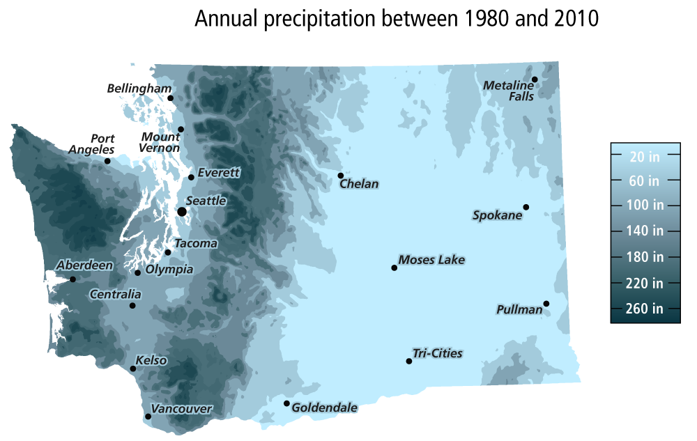
Water is a resource needed by all living things. Washingtonians use water for drinking, cleaning, agriculture, and recreation, among other things. Washington State has many different climates, with variable water resource needs. West of the Cascade Range, precipitation is plentiful. Western Washington actually receives four times more rainfall than the eastern side of the state, where there is a greater need for water resources.
According to the Environmental Protection Agency (EPA), 75 percent of Washington’s total water supply is from surface water and 25 percent is from groundwater. However, over 60 percent of drinking water in Washington State is supplied by groundwater. Groundwater is therefore an important resource for millions of people in Washington.
The water cycle
The hydrologic cycle or water cycle is the process of water moving and changing from water vapor to precipitation. Precipitation (rain and snow) that falls on the land or water eventually evaporates to water vapor and enters into the atmosphere again. Important steps in this process are evaporation, condensation, precipitation, runoff, and transpiration.
- Evaporation is when a liquid turns into a gas. Water from oceans, lakes, and rivers evaporates to become water vapor in the atmosphere.
- Condensation is the opposite of evaporation. It happens when a gas becomes a liquid. In the atmosphere, water vapor condenses to make clouds.
- Precipitation is the liquid (rain) or solid (snow and hail) form of water that falls from the clouds to the Earth.
- Runoff is the movement of rain and meltwater on the surface of the earth to lakes, rivers, streams, and ultimately the ocean.
- Transpiration and evapotranspiration is the release of water vapor from plants and soils.
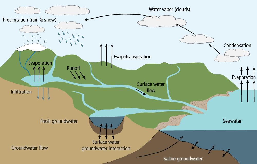
Once precipitation falls to the ground, it travels many different paths. On the surface, water travels in streams and rivers to bodies of water such as lakes or the ocean. Water from the surface also infiltrates into the ground, resupplying groundwater. This water can continue to flow underground.
What is an aquifer?
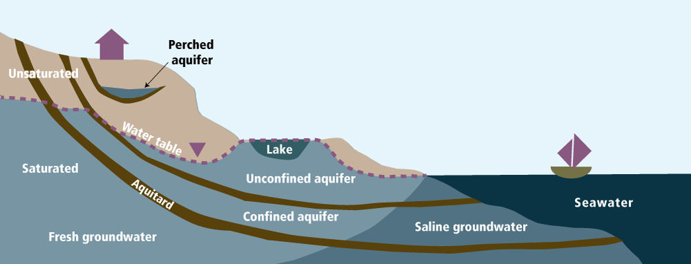
When water contacts the surface of the earth, it starts to soak into the ground. The water travels down and collects between sand and gravel grains, or fills cracks in rocks. The underground location where the water collects is called the saturated zone. When there is enough water in the saturated zone to be pumped (by a well, for example) it is called an aquifer.
Washington has seven principal aquifers as defined by the United States Geological Survey’s (USGS) Ground Water Atlas of the United States. A principal aquifer is a regional, extensive aquifer or aquifer system with the potential to be used as a source of drinking water. The water in these aquifers can be close to or just feet below the land surface to hundreds of feet deep. In western Washington, the aquifers are primarily made of loose to compact layers of sediment left by the glaciers that covered the area thousands of years ago. On the east side of the state, many aquifers are weathered surfaces and sedimentary deposits between lava flows.

Types of aquifers
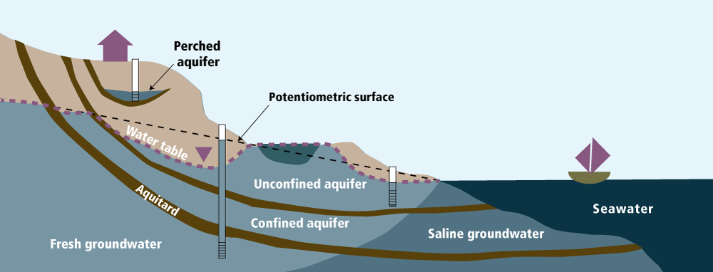
Aquifers are either confined, unconfined, or a combination of the two.
Confined aquifers are usually trapped between hard and (or) compact layers, much like a sandwich. The upper and lower layers do not allow fluid to pass through them easily. These hard or compact layers can be rock or clay and are called aquitards. Wells drilled into confined aquifers are often called artesian wells.
Some aquifers form as limited volumes of water trapped above an aquitard. These are called perched aquifers. Their water levels vary greatly and rely on recharge from rain or snow. Therefore, the water level is often affected by seasonal changes in precipitation, with lower water volumes available when there is less precipitation.
An unconfined aquifer is shallow and closer to the ground surface, and only partially surrounded by an aquitard. The water can come into direct contact with the atmosphere and surface water bodies such as lakes and rivers. An unconfined aquifer is also called a water table aquifer.
Aquifers in Washington
Each of these types of aquifers exist in Washington. In western Washington’s aquifers, sediments deposited tens of thousands of years ago host aquifers both near to and deep beneath the surface. Aquitards created by dense layers of material create confined and perched aquifers that we pump water from.
Eastern Washington has vast areas covered by Columbia River Basalt (CRBs), a series of flood basalts. Flood basalts are large volcanic eruptions where a great deal of lava is erupted and covers an extensive area. The CRBs are between 6–17 million years old, and they erupted through cracks in the ground near the border of Washington, Idaho, and Oregon.
The tops and bottoms of the individual CRB lava flows act in opposite ways when it comes to water. Enough time passed between lava flow events that the tops of the flows hardened to rock and weathered, breaking into pieces that accumulated on the ground surface. These weathered surfaces (vesicular flow tops) include all sorts of nooks and crannies that allow water to pass through, and where aquifers have since formed. The dense flow interiors created aquitards that stop the flow of water between the aquifers, thereby creating confined aquifers. Unconfined aquifers are only found in the very top surfaces of the CRBs which were not covered by another lava flow.

Surface water/groundwater interaction
Groundwater and surface water perform a sort of dance as water moves underground and resurfaces again. Sometimes the surface water body contributes runoff to the groundwater through infiltration. However, groundwater can also contribute to the surface water body. This can change from season to season or over a period of years. Many water bodies in Washington State, such as rivers, streams, reservoirs, and lakes, are connected to aquifers and therefore can be greatly affected by changes created by man-made and (or) natural processes. Pumping too much water from an aquifer can reduce the amount of water in a nearby lake or stream, and reduce water quality.

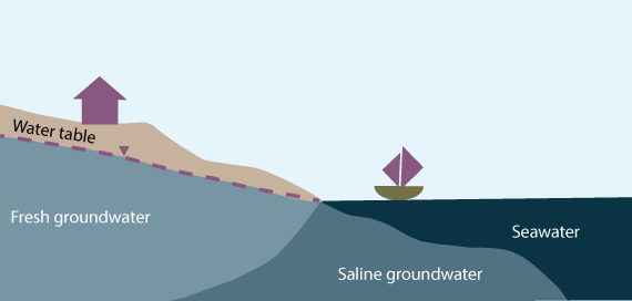
Along Washington’s coasts, surface water-groundwater interaction also occurs where aquifers are in connection with the ocean. The water level and water chemistry of groundwater can be altered when saline seawater mixes with fresh groundwater. Groundwater level changes with the tides. Where groundwater and seawater meet is a zone of saline groundwater. Freshwater is less dense than saltwater, so freshwater lays on top of the saltwater in a curve, as seen in the figure below.
Groundwater and climate
Extreme weather
Weather plays a crucial role in groundwater resources. Precipitation is responsible for filling our streams and lakes and allows for infiltration of water to recharge our aquifers. Heatwaves and droughts have become more common in the last 50 years. With heatwaves, groundwater resources will be in higher demand while droughts decrease water supply. Droughts can also cause reduced snowpack in the mountains. When the snowpack melts in spring and summer, it supplies water to reservoirs at a time when precipitation is usually low.
Sea level rise
As a result of global warming, ocean waters are warming, too. As water warms, it expands and occupies more space. At the same time, global warming melts land-based ice sheets and glaciers that contribute more water to the oceans. For these reasons, sea levels are on the rise.
Coastal communities in western Washington will be impacted by sea level rise, which will continue to push the contact between the freshwater aquifers and saline seawater farther inland. This inputs poor water quality into our already limited supply of groundwater, reducing the amount of water available to communities. It will be necessary to find alternative sources of freshwater or bear the expense of treating poor-quality water for consumption.

Sea level at present is relatively low (just like in this image), and therefore the saline/freshwater interface is closer to the shoreline.
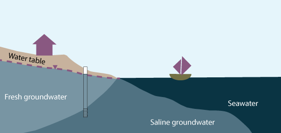
As sea level rises more, saline water moves further inland, seeping into wells and creating poor water quality.
Water rights
What are water rights in Washington?
In Washington State, water belongs to the public and cannot be owned. However, the “right” to use the water is authorized by the State. Water rights are managed by the Washington Department of Ecology. A water right is granted for a certain purpose, specified amount, and designated use in a specific location. Water rights allow for the use and protection of water resources. These resources include adequate quantities of water for groundwater and surface water bodies, habitat for fish and wildlife, recreation, scenic and aesthetic values of natural settings, water quality, and navigation of water vessels.
The State follows the legal ‘doctrine of prior appropriation’ established in historical Western Water Law in the 1800s. The doctrine states that persons with water rights issued to them prior to others will have first right to use the water. This is also called, “first in time, first in right.”
Please visit the Department of Ecology website for more details as well as information on how to obtain a water right.
Wells: How do we get water from the ground?
Homeowners can access groundwater from their own wells or from public supply wells. To get to groundwater, you have to drill a hole in the ground and construct a well. A licensed well driller will construct a well using a drilling rig to drill a hole and install appropriate seals, casing, and pump. The hole is drilled in the ground and lined (cased) as needed to hold the hole open. The space between the hole and the casing—the annulus—must be sealed at the surface and can have filter pack (usually silica sand), and additional seals as needed to keep water from migrating along the casing. Casing can also include screens or perforations that allow water to move inside the casing to the pump, but they block sediment entering from the surrounding material. The casing type will depend on its use, depth, and geology encountered. Inside of the casing, a pump is installed and the water is then pumped to the surface for use.
The following is a simple schematic of an irrigation well with a pump.

Homeowner’s Guide to Well Construction is provided by Department of Ecology.
For well reports for your well or other wells in your area, check this search at Ecology.
The water level in a well is not always what you’d expect. Confined aquifers are surrounded by impermeable aquitards. The aquitards exert pressure on the water in the confined aquifer, and this can cause the water level in the well to be pushed up higher than the top of the aquifer. In other words, you may not need to drill all the way down to the actual rock layer where the water is stored. A shallower well may be enough to reach the water.
Wells into perched aquifers and water table wells, on the other hand, are not under nearly as much pressure. The water in these wells stays relatively level with the aquifers. If you connect an imaginary line between the water levels in the wells and sea level (see image below), this is known as the potentiometric surface.
How is water quality determined?
Groundwater quality is greatly affected by what happens around it. Naturally-occurring elements are introduced into the water from the rocks around it. The surrounding rocks can contribute elements such as iron, manganese, sodium, fluoride, nitrate, and sulfate. Unacceptable concentrations of these elements can lead to poor water quality that can damage the well, piping, and household plumbing. For example, high concentrations of iron in the water can lead to rust staining on plumbing fixtures and clogging of pipes. Concentrations above acceptable limits are also not safe for human consumption. Human activities, such as septic tanks and the use of agricultural fertilizer, introduce biological and chemical contaminants that also make groundwater undrinkable.
Water quality standards are set by Washington Administrative Code (WAC). Authority is given to the Washington State Department of Ecology through the Revised Code of Washington (RCW).
Chapter 173-200 WAC-Water Quality Standards for Groundwaters of the State of Washington. The limits of contaminants in groundwater, primarily for drinking water, are listed in a table in section 40.
How can I conserve water?
The amount of groundwater varies depending on the aquifer. Some aquifers are quickly replenished by surface waters within a few decades, while others take thousands of years to be replenished. When more water is taken out of an aquifer than is put in, it is called overdraft or groundwater mining. Seasonally, there are variations as more water is used in summer than in winter months. However, when a continued trend of falling water level is observed, groundwater mining is taking place. Therefore, water-use awareness and conservation is important so that we can balance recharge and withdrawal to maintain enough water for current and future uses.
For water conservation information and tips, visit "Water—use it wisely".
What we do at the Washington Geological Survey
National Groundwater Monitoring Network
In 2018, WGS received grant funding from the USGS to become a data provider for the National Groundwater Monitoring Network (NGWMN). WGS, in partnership with local water agencies, obtains and curates groundwater level and quality data. A subset of these wells are selected that fit the criteria required for the NGWMN. WGS data is provided to the NGWMN, where it is then distributed to the public through the NGWMN map services and data downloads. Currently, WGS is in partnership with Thurston, Kitsap, and Island Counties.

DNR groundwater monitoring network
The Department of Natural Resources has many wells throughout the state that are used on state-managed land leases for agriculture and as drinking water for livestock. In partnership with the Product Sales and Leasing Division, WGS has performed water level measurements and data compilation of wells located in DNR’s Southeast Region. Many wells have data from the 1970s to the present. This data will prove invaluable when determining water availability for current and future leasing.
Rilette geophysical groundwater project
In 2012, the Department of Ecology started a hydrogeologic investigation associated with the Columbia River Off-Channel Aquifer Storage Project. The project aims to achieve energy grid balance: balancing the supply and demand of electricity. Having too much energy supply relative to demand is wasteful, since the excess energy cannot be stored. Having insufficient energy supply relative to demand means customers don't get the heating or air conditioning they need, and can lead to energy blackouts.
The hydrogeologic investigation is located in Douglas County, Washington, about 5 miles south of the Columbia River and 20 miles west of the town of Grand Coulee. During times of high supply but low demand, the excess energy can be used to pump water from the Columbia River to an aquifer at higher elevation. During times of low supply but high demand, the water in the aquifer can be pumped down with the aid of gravity into a hydroelectric generator, creating an energy surplus that can be sold to power companies.
In 2019, WGS began working with the Department of Ecology using geophysical techniques to test the feasibility of the plan described above. We are using geophysical investigation methods to determine if the aquifer is confined, outline the boundaries of the aquifer, and track water movements within the aquifer.
Pasco Basin hydrogeologic framework modeling
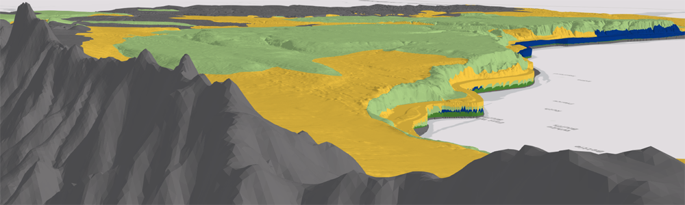
WGS helped convert a model of geologic layers and aquifers (a hydrogeologic model) in the Pasco Basin of southeastern Washington into a 3D visualization. The data for the model were taken from the following publication by the U.S. Geological Survey’s Water Science Center:
Heywood, C. E.; Kahle, S. C.; Olsen, T. D.; Patterson, J. D.; Burns, Erick, 2016, Simulation of Groundwater Storage Changes in the Eastern Pasco Basin, Washington: U.S. Geological Survey Scientific Investigations Report 2016–5026, 56 p., 1 plate. [https://pubs.er.usgs.gov/publication/sir20165026]
The Pasco Basin forms parts of Grant, Adams, and Franklin Counties in the Tri-Cities area of southeastern Washington. The model consists of six 3D layers, representing the upper extents of five sedimentary hydrogeologic rock units. Columbia River Basalt lava flows make up the bedrock in this area. These basalts are overlain by as much as several hundred feet of clay, silt, sand, and gravel of the Ringold and Hanford Formations. The visualization displays the hydrogeologic units as well as the 846 boreholes used to develop the model.
